Language
OneAtlas Basemap APIs
Welcome to our OneAtlas Basemap guide. You will learn how to access the Basemap streaming service in order to display the Basemap imagery layer in your working environment or to integrate it in your application.
About
OneAtlas Basemap is a worldwide off-the-shelf imagery layer made from Airbus highest-grade satellite imagery. Sharp and constantly refreshed, it provides the most reliable context to you.
- Worldwide off-the-shelf layer: Complete and consistent coverage of all earth landmasses
- Highest-grade only: Curated satellite imagery, with marginal cloud cover
- Sharp: 1.5m over the world, 50cm and 30cm over the most populated urban areas. Precisely geolocated
- Fresh: Constantly refreshed
The Basemap can be accessed as a streaming service allowing users to display the Basemap imagery layer in full resolution without having to download anything.

The streaming service is served using the Web Map Tile Service (WMTS) simple profile standard defined by the Open Geospatial Consortium (OGC) https://www.ogc.org/standards/wmts. It is currently available in epsg:3857 projection. You can find an overview of the Basemap most important WMTS principles in the WMTS basics section.
Note: Access to the Basemap can be worldwide or geofenced. Geofenced means that a user is authorized to stream only part of the Basemap. If the access is geofenced, white tiles are returned over areas out of the allowed area.
Typical applications to display map streaming services are Geographic Information Systems (GIS) such as QGIS or ArcMap/ArcGIS. But the Basemap can be displayed in any kind of application compatible with WMTS. You can also display the Basemap in your own application as soon as it is compatible with WMTS standard.
Note: the Basemap content is also available for download or physical delivery, but these pages only describe streaming access. You can request download or physical deliveries info at intelligence-customer_care@fr.airbus.com
Whatever the application displaying the Basemap, it acts as a WMTS client using APIs defined by the standard. APIs are HTTPs requests that the client send to the Basemap server, which answers as per the WMTS standard.
Before using our APIs, you need to refer to the Basemap access section to learn how to create your OneAtlas account and get your Basemap streaming access.
Once your account is created and your access is granted, read the Authenticate section to discover how to generate the identifiers needed to access to the Basemap streaming service.
The Streaming from API section explains how to retrieve Basemap data from the APIs.
The Streaming from GIS section describes how to display the Basemap layer in your GIS.
The WebApplication Integration section provides the best practice to integrate the Basemap in your WebApp.
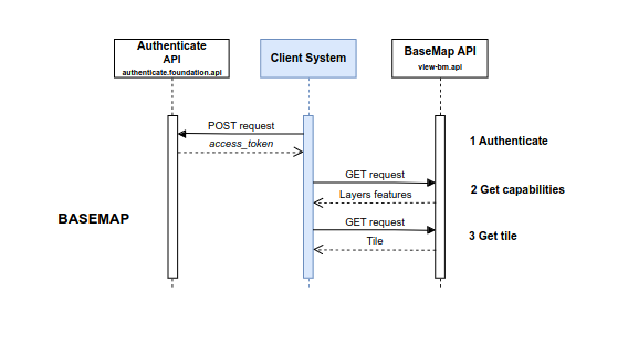
Workflow

© Airbus Defence and Space 2022. All rights reserved. Privacy Policy | Legal Information