Language
WorldDEM API
The WorldDEM Portal & API solution grants fast and easy access to all our WorldDEM off-the-shelf products via a portal or API. Both solutions provide global* access to WorldDEM™Neo, WorldDEM™, WorldDEM4Ortho, WorldDEM DTM Lite and WorldDEM 30.
The API for WorldDEM is provided upon the receipt of order, which allows direct access to the product. The consumption can be monitored and tracked online. Even very small Areas of Interest (AOI) may be downloaded, allowing you to exactly define individual AOIs.
*On demand release request for sensitive countries
What is WorldDEM™ Neo?
WorldDEM Neo is our new Digital Surface Model (DSM), globally available with 5m pixel spacing and fresh data acquisitions (data currency from 2017-2021) with unprecedented quality and accuracy. WorldDEM Neo provides a high resolution and precise reference layer to enhance a wide range of applications.
For more information: Product description
What is WorldDEM4Ortho?
WorldDEM4Ortho is an elevation information layer optimised for the orthorectification of high-resolution (HR) and very high resolution (VHR) optical satellite data. WorldDEM4Ortho is the most consistent, homogenous and accurate elevation model for high-quality image orthorectification on a global scale.
For more information: Product description
What is WorldDEM Neo DTM Level 1?
WorldDEM Neo DTM Level 1 is a Digital Terrain Model, providing a continuous distribution of terrain heights derived from the WorldDEM Neo DSM. Elements over the surface of the Earth with a vertical dimension, such as buildings or forests are identified and their heights transformed to bare ground. The characteristic of the relief, as well as specific features such as dams, for example are conserved.
For more information: Product description
Characteristics
| WorldDEM Streaming Service | |
|---|---|
| WorldDEM™ Neo | A new Digital Surface Model (DSM), globally available with 5m pixel spacing and fresh data acquisitions (data currency from 2017-2021) in unprecedented quality and accuracy. WorldDEM Neo provides a high resolution and precise reference layer. |
| WorldDEM4Ortho | A global elevation information layer (24m posting) optimised for the orthorectification of high-resolution (HR) and very high resolution (VHR) optical satellite imagery. |
| WorldDEM Neo DTM - Level 1 | A Digital Terrain Model (DTM), providing a continuous distribution of terrain heights derived from the WorldDEM Neo DSM. |
| Format | GeoTIFF (32 Bit Floating point) |
| Min. AOI size | 1 m² (rounded up to 1 km²) |
| Max. AOI size per request | 15.000 km² or 3 by 3 degrees of latitude and longitude |
| More Information | WorldDEM Product Specification |
Contact
You can obtain your WorldDEM subscription through the OneAtlas. For further information please contact our Customer Service.
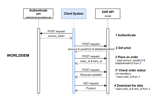
Workflow

© Airbus Defence and Space 2022. All rights reserved. Privacy Policy | Legal Information