Language
Search & Display image of the California wildfire
Discover the full capabilities of OneAtlas through this tutorial which describes how to use the API to study the impact of wildfires in California. The 2018 wildfire season was the most destructive wildfire season ever recorded in California. Satellite imagery helps to measure the extent of the damage. Through this tutorial, you will discover how to search images in an area and stream the images over the weeks around the wildfires.
Authenticate
Before you can get started, you first need the key to open the door to our APIs! You can get your API Key by signing into your OneAtlas account and using our API Key Generator. Make sure to keep this safe, you will need this in the next step.
Don’t yet have a OneAtlas Account? Feel free to contact us via our main OneAtlas page.
Next you need to use the /auth/realms/IDP/protocol/openid-connect/token endpoint, replacing your API key which you have generated before.
r = requests.post('https://authenticate.foundation.api.oneatlas.airbus.com/auth/realms/IDP/protocol/openid-connect/token',
                  headers={'Content-Type':'application/x-www-form-urlencoded'},
                  data={'apikey':<api_key>, 'grant_type':'api_key', 'client_id':'IDP'})

token = r.json()['access_token']
You will be provided with an access token:
{
    "access_token": "<access_token>",
    "expires_in": 3600,
    "refresh_expires_in": 0,
    "token_type": "bearer"
}
Search images
You have the possibility to search images using opensearch with custom parameters. The quicklook will enable you to display the image and see if this image corresponds to your needs.
Opensearch
Searching our Living Library is simple. All you need to do is call the /opensearch endpoint and provide parameters in compliance with OpenSearch standard. These parameters can include a bounding box, GeoJSON polygon, dates and more.
For more information about these filters, take a look at some examples in the Search Guide
In this tutorial, we will use some filters to search images :
- Display of Pléiades images only
- Display of images around our area of interest
- acquisition dates around the wildfires
params = {
    'lat': 39.812939,
    'lon': -121.402845,
    'format':'image/jp2',
    'constellation':'PHR',
    'acquisitionDate':'[2016,2019[',
    'sortBy':'acquisitionDate',
    'processingLevel':'SENSOR'
}

r = requests.get('https://search.foundation.api.oneatlas.airbus.com/api/v2/opensearch',
                 headers={'Content-Type':'application/json', 'Authorization':f'Bearer {<token>}'},
                 params=params)

r_search = r.json()
Note: When searching, you will receive results from the full catalog as well as the Living Library. If you want to search only Living Library results, you will need to filter using
processingLevel. This value could be equal to SENSOR (images which meet Living Library criteria) and ALBUM (images that do not meeting Living Library criteria in terms of incidence angle and cloud cover. They can not be streamed on-the-fly but you will be able to order them soon, for delivery in your private workspace). Below is an example of a call:
curl -X GET \
  'https://search.foundation.api.oneatlas.airbus.com/api/v1/opensearch?processingLevel=SENSOR' \
  -H 'Authorization: Bearer <access_token>' \
  -H 'Cache-Control: no-cache' \
This will return 4 images according to your search parameters.
{
    "error":"false"
    "features" : [] #4 items
    "itemsPerPage":50
    "startIndex":0
    "totalResults":4
    "type":"FeatureCollection"
}
The first feature look like :
{
    "_links": {
        "delete": {
            "href": "https://workspaces.foundation.api.oneatlas.airbus.com/api/v1/workspaces/0e33eb50-3404-48ad-b835-b0b4b72a5625/items/0b714827-923b-4eb7-9946-914870670927",
            "name": "Delete",
            "type": "HTTP"
        },
        "imagesGetBuffer": [
            {
                "href": "https://access.foundation.api.oneatlas.airbus.com/api/v1/items/0b714827-923b-4eb7-9946-914870670927/images/7ebe5ba4-fafd-4b91-ae11-04c637dffa25/buffer",
                "name": "panchromatic",
                "resourceId": "7ebe5ba4-fafd-4b91-ae11-04c637dffa25",
                "type": "getBuffer"
            },
            {
                "href": "https://access.foundation.api.oneatlas.airbus.com/api/v1/items/0b714827-923b-4eb7-9946-914870670927/images/9d594bc8-a632-4cdc-a619-d99636fb57a9/buffer",
                "name": "multispectral",
                "resourceId": "9d594bc8-a632-4cdc-a619-d99636fb57a9",
                "type": "getBuffer"
            }
        ],
        "imagesMetadata": [
            {
                "href": "https://access.foundation.api.oneatlas.airbus.com/api/v1/items/0b714827-923b-4eb7-9946-914870670927/images/7ebe5ba4-fafd-4b91-ae11-04c637dffa25/metadata",
                "name": "panchromatic",
                "resourceId": "7ebe5ba4-fafd-4b91-ae11-04c637dffa25",
                "type": "application/geo+json"
            },
            {
                "href": "https://access.foundation.api.oneatlas.airbus.com/api/v1/items/0b714827-923b-4eb7-9946-914870670927/images/9d594bc8-a632-4cdc-a619-d99636fb57a9/metadata",
                "name": "multispectral",
                "resourceId": "9d594bc8-a632-4cdc-a619-d99636fb57a9",
                "type": "application/geo+json"
            }
        ],
        "imagesWcs": [
            {
                "href": "https://access.foundation.api.oneatlas.airbus.com/api/v1/items/0b714827-923b-4eb7-9946-914870670927/images/7ebe5ba4-fafd-4b91-ae11-04c637dffa25/wcs",
                "name": "panchromatic",
                "resourceId": "7ebe5ba4-fafd-4b91-ae11-04c637dffa25",
                "type": "WCS"
            },
            {
                "href": "https://access.foundation.api.oneatlas.airbus.com/api/v1/items/0b714827-923b-4eb7-9946-914870670927/images/9d594bc8-a632-4cdc-a619-d99636fb57a9/wcs",
                "name": "multispectral",
                "resourceId": "9d594bc8-a632-4cdc-a619-d99636fb57a9",
                "type": "WCS"
            }
        ],
        "imagesWms": [
            {
                "href": "https://access.foundation.api.oneatlas.airbus.com/api/v1/items/0b714827-923b-4eb7-9946-914870670927/images/7ebe5ba4-fafd-4b91-ae11-04c637dffa25/wms",
                "name": "panchromatic",
                "resourceId": "7ebe5ba4-fafd-4b91-ae11-04c637dffa25",
                "type": "WMS"
            },
            {
                "href": "https://access.foundation.api.oneatlas.airbus.com/api/v1/items/0b714827-923b-4eb7-9946-914870670927/images/9d594bc8-a632-4cdc-a619-d99636fb57a9/wms",
                "name": "multispectral",
                "resourceId": "9d594bc8-a632-4cdc-a619-d99636fb57a9",
                "type": "WMS"
            }
        ],
        "imagesWmts": [
            {
                "href": "https://access.foundation.api.oneatlas.airbus.com/api/v1/items/0b714827-923b-4eb7-9946-914870670927/images/7ebe5ba4-fafd-4b91-ae11-04c637dffa25/wmts",
                "name": "panchromatic",
                "resourceId": "7ebe5ba4-fafd-4b91-ae11-04c637dffa25",
                "type": "WMTS"
            },
            {
                "href": "https://access.foundation.api.oneatlas.airbus.com/api/v1/items/0b714827-923b-4eb7-9946-914870670927/images/9d594bc8-a632-4cdc-a619-d99636fb57a9/wmts",
                "name": "multispectral",
                "resourceId": "9d594bc8-a632-4cdc-a619-d99636fb57a9",
                "type": "WMTS"
            }
        ],
        "quicklook": {
            "href": "https://access.foundation.api.oneatlas.airbus.com/api/v1/items/0b714827-923b-4eb7-9946-914870670927/quicklook",
            "name": "QuickLook",
            "type": "HTTP"
        },
        "thumbnail": {
            "href": "https://access.foundation.api.oneatlas.airbus.com/api/v1/items/0b714827-923b-4eb7-9946-914870670927/thumbnail",
            "name": "Thumbnail",
            "type": "HTTP"
        },
        "wms": {
            "href": "https://access.foundation.api.oneatlas.airbus.com/api/v1/items/0b714827-923b-4eb7-9946-914870670927/wms",
            "name": "WMS",
            "type": "WMS"
        },
        "wmts": {
            "href": "https://access.foundation.api.oneatlas.airbus.com/api/v1/items/0b714827-923b-4eb7-9946-914870670927/wmts",
            "name": "WMTS",
            "type": "WMTS"
        }
    },
    "geometry": {
        "coordinates": [
            [
                [
                    -121.6342241121392,
                    40.01729501639826
                ],
                [
                    -121.377538588148,
                    40.02948027141388
                ],
                [
                    -121.3791205074043,
                    39.6738373702358
                ],
                [
                    -121.6348867556071,
                    39.66054199225062
                ],
                [
                    -121.6342241121392,
                    40.01729501639826
                ]
            ]
        ],
        "type": "Polygon"
    },
    "properties": {
        "acquisitionDate": "2016-12-21T19:03:33.306Z",
        "acquisitionIdentifier": "DS_PHR1B_201612211903333_FR1_PX_W122N39_0621_02996",
        "acquisitionStation": "FR1",
        "archivingCenter": "FR1",
        "azimuthAngle": 179.9848966869066,
        "cloudCover": 0.75,
        "commercialReference": "SO18006327",
        "constellation": "PHR",
        "correlationId": "71f71a8d-8504-42d4-bb9f-3f03c9d84f07",
        "dataUri": "gs://tcifg-idp-prod-datastore-data-pilot-nearline/R_PHR2016_Q4_10_176_SO18006327-76-01_DS_PHR1B_201612211903333_FR1_PX_W122N39_0621_02996.zip",
        "expirationDate": "2020-02-23T02:25:38.73542233Z",
        "format": "image/jp2",
        "id": "0b714827-923b-4eb7-9946-914870670927",
        "illuminationAzimuthAngle": 164.4056179808057,
        "illuminationElevationAngle": 25.293884733098,
        "incidenceAngle": 24.3188992240007,
        "incidenceAngleAcrossTrack": 6.536331698767763,
        "incidenceAngleAlongTrack": -23.61245854581714,
        "organisationName": "AIRBUS DS GEO",
        "parentIdentifier": "DS_PHR1B_201612211903333_FR1_PX_W122N39_0621_02996",
        "platform": "PHR1B",
        "processingCenter": "FCMUGC",
        "processingDate": "2018-03-18T08:14:04.812",
        "processingLevel": "SENSOR",
        "processorName": "DRS-MM V2.5vV2.5",
        "productCategory": "image",
        "productType": "bundle",
        "productionStatus": "IN_CLOUD",
        "publicationDate": "2019-02-23T02:25:38.73542233Z",
        "qualified": false,
        "resolution": 0.5,
        "sensorType": "OPTICAL",
        "snowCover": 99.86,
        "sourceIdentifier": "DS_PHR1B_201612211902573_FR1_PX_W122N39_0621_02992",
        "spectralRange": "VISIBLE",
        "title": "DS_PHR1B_201612211902573_FR1_PX_W122N39_0621_02992",
        "workspaceId": "0e33eb50-3404-48ad-b835-b0b4b72a5625",
        "workspaceName": "public",
        "workspaceTitle": "Public"
    },
    "rights": {
        "browse": {},
        "wms": {},
        "wmts": {}
    },
    "type": "Feature"
}
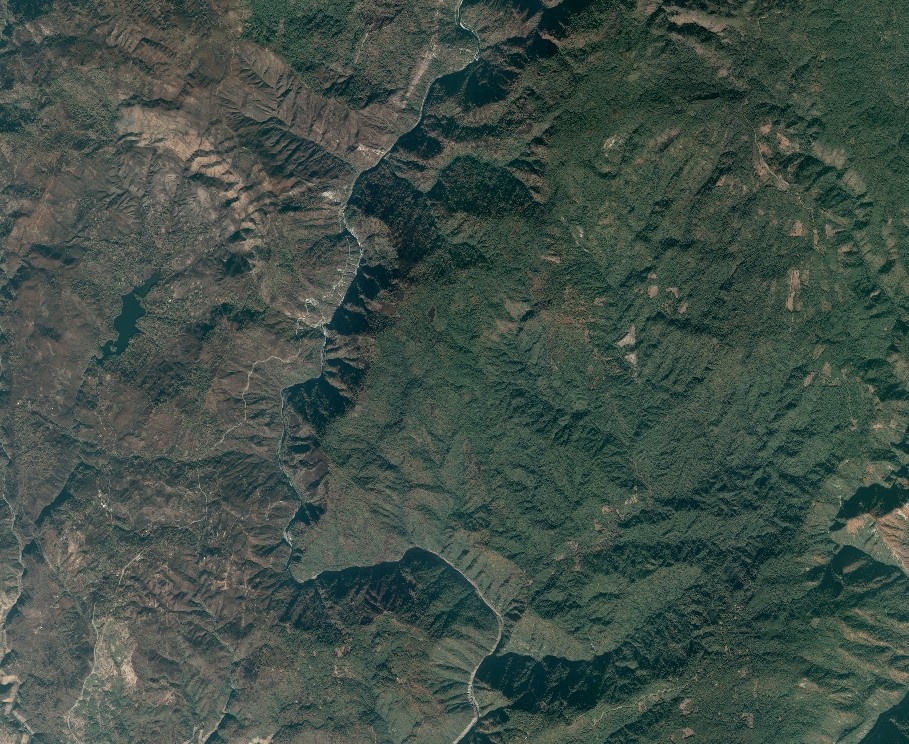
Quicklook
We will now display the first result of our research by requesting its quicklook.
feature = r_search['features'][-1]

r = requests.get(feature['_links']['quicklook']['href'],
                 headers={'Authorization':f'Bearer {token}'})

quicklook = load_image(r)

save_and_display_image(quicklook, 'quicklook.jpg')
Tiles
Our search APIs allow you to receive mapping tiles in both WMS and WMTS streaming formats.
Consult our View service guide to learn more about the WMTS streaming format.
WMTS
The example below shows a WMTS request.
This will return the GetCapabilities XML file for the image you wish to stream.
We have to extract the template to request tiles.
r = requests.get(feature['_links']['wmts']['href'],
                 headers={'Authorization':f'Bearer {token}'})

xml = extract_xml(r)

template = extract_template(xml)

print_wmts(xml)
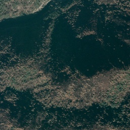
One tile
We will now display one tile. You will need to enter the following WMTS parameters:
- style
- projection (tile matrix set) : here we choose WebMercator projection EPSG:3857
- zoom (tile matrix)
- column & row
- Get the tile column & row with our converter
Python users can access this with the mercantile library:
# Basic parameters
style = 'rgb'
projection = 'EPSG3857' # WebMercator projection EPSG:3857
zoom = 14 # around 10m resolution

# Get col & row match lon & lat & zoom according to the WebMercator projection
origin = mercantile.tile(params['lon'], params['lat'], zoom)
col = origin.x
row = origin.y

# Format the wmts template
formatted_template = format_template(template, style, projection, zoom, col, row)

# Request the tile using it
r = requests.get(formatted_template,
                 headers={'Authorization':f'Bearer {token}'})

tile = load_image(r)
save_and_display_image(tile, 'tile.jpg')
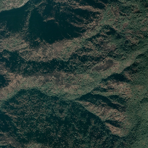
Large tiled image
It is possible to request n*n tiles to build a large tiled image.
n_tiles = 2 # large image = n*n tiles
large_tile = build_large_tile(token, template, zoom, origin, n_tiles)
save_and_display_image(large_tile, 'large_tile.jpg')
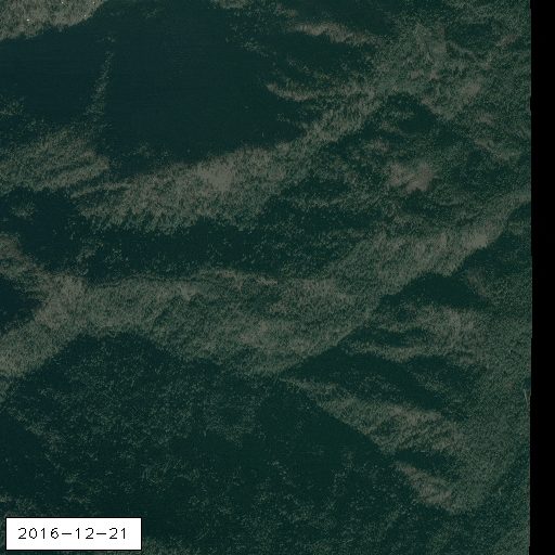
In time
Finally, we can build a gif to have a sweet time comparison.
features = r_search['features']

request_images_and_build_gif(token, features, zoom, origin, n_tiles, 'in_time')

display_saved_image('in_time.gif')
The gif quality has been reduced for the web display.
We want to hear from you. If you require assistance, please contact the support by clicking on Contact Us.
See the whole code on GitHub.
© Airbus Defence and Space 2022. All rights reserved. Privacy Policy | Legal Information